Two lanes of the southbound New York State Thruway (I-87/I-287) in Tarrytown will be closed between 7 p.m. and 6 a.m. during every overnight next week (Monday evening, Mar. 9 through Saturday morning, Mar. 14). The one-mile closures from the toll plaza to just north of exit 8A (Elmsford – NY Route 119 – Saw Mill River Parkway North) are necessary to perform work on an electronic highway sign structure. Two lanes of the southbound Thruway will remain open during the closures.
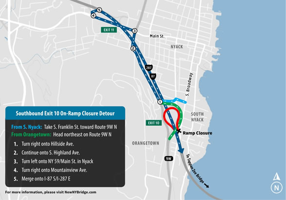
In addition, the exit 10 on-ramp to the southbound Thruway in South Nyack will be closed from 9 p.m., Tuesday, Mar. 10 to 5 a.m., Wednesday, Mar. 11. The closure will allow Tappan Zee Constructors, LLC (TZC) to continue restriping the roadway and moving temporary barriers. Drivers will be directed to use the entrance ramp located on Route 59 in Nyack.
All of this planned work is subject to postponement due to weather conditions.
Starting the week of Mar. 9 and continuing for approximately two weeks, TZC will construct the South Nyack abutment foundations. Located near the Thruway’s northbound access ramp in Rockland County, the operation will include the installation of sheet piles to support the exiting roadway. TZC will install the sheet piles during daytime work hours and will utilize noise attenuation techniques to minimize impacts to residents.
Crews also will continue working on the bridge’s landings on the Rockland and Westchester shorelines. The abutments, which will be made of steel and concrete, will serve as strong bases where the new crossing meets the landside roadway.
Ice buildup on the Hudson River will continue to limit operations at the project site during the week of Mar. 9. TZC has included a two-month winter shutdown in its schedule to account for winter weather conditions.
TZC’s inclement weather preparation protocols include having tug boats on the water at all times, inspecting and adjusting all mooring lines, inspecting crane barges and securing all equipment, moving the large majority of cranes to shallow water moorings and taking all smaller crew boats out of the water. Additionally throughout every storm, TZC uses video and GPS to monitor the entire fleet of project vessels from its security operations center.
Pile Driving and Other Construction Activity
When weather permits, workers will continue placing foundations for the new bridge. The work includes pile driving from 7 a.m. to 7 p.m., Monday through Friday and noon to 7 p.m., Saturday.
TZC also will continue limited concrete placement for foundations near the South Nyack shoreline. The concrete for this work is being acquired from local concrete suppliers and delivered by truck to the Rockland trestle located off the Thruway’s southbound access ramp. Trucks exit the trestle to the Thruway via the northbound access ramp. The access ramps are used only by construction vehicles, providing a safe route directly to the work site and reducing traffic impacts on local roads.
Additional work includes:
- Pile cap foundation construction
- Main span foundation construction
- River Road utility work
- Support for river-based work from the Rockland trestle
- Survey inspections on the existing bridge
Boater Safety
The U.S. Coast Guard has established a Safety Zone surrounding 16 construction barge mooring locations at the project site. No unauthorized vessels are allowed in the Safety Zone. In addition, marine law enforcement will be enforcing the rules of the expanded Regulated Navigation Areas (RNAs) east and west of the Safety Zone. The RNAs stretch 500 yards north and 500 yards south of the existing bridge. Boaters are urged to transit the main channel with no wake at a maximum speed of 5 knots, and to use extreme caution on the river at all times.
More New NY Bridge boater safety information, including the U.S. Coast Guard Notice to Mariners and construction site maps, can be found here at NewNYBridge.com. An interactive map showing vessel locations on the Hudson River is also available here for recreational and commercial boaters to get updated information on this very active construction zone. The GPS tracking map is for informational purposes and not intended for navigation.
Mariners also should be aware that TZC will continue work in the vicinity of the side channels under the existing bridge. Additional temporary navigational lights have been installed to further define the 600-foot navigation channel under the main span. Permanent elements of the new bridge are lit per U.S. Coast Guard requirements, as are all moorings, barges and other equipment.
All lane closures are subject to change due to traffic, weather or emergency situations. Please visit https://www.thruway.ny.gov/travelers/map/index.html?layer=incidents for real-time information regarding traffic conditions.