On Monday, Jan. 11, Tappan Zee Constructors, LLC (TZC) will begin the first phase of constructing a noise barrier along the northbound New York State Thruway (I-87/I-287) in South Nyack. The operation will include demolishing an existing retaining wall between the Thruway and the parking lot of the Eagle Rock apartments on Piermont Ave. A temporary noise-reducing fence and concrete barrier will be installed as the demolition occurs. The second phase of work, which includes the construction of new retaining walls and foundations, will follow once demolition is complete.
Next week also will see continued construction of foundations for noise barriers along the southbound Thruway between the South Broadway bridge and River Road. This construction work involves drilling holes into the soil to install foundations. After the foundations are installed, concrete panels that form the noise barriers will be installed. The barriers will be treated with sound-absorbing material to further reduce traffic noise to the nearby community.
All-Electronic Toll Collection Gantry Work
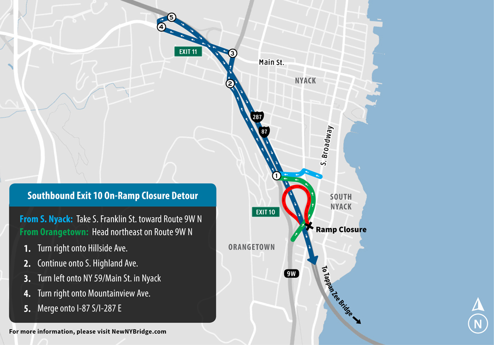
Construction of the project’s temporary all-electronic toll collection (AETC) system in Rockland will continue near the exit 10 (Nyack – South Nyack – US Route 9W) on-ramp to the southbound Thruway. The work will necessitate closing the on-ramp during the overnights of Wednesday, Jan 13 through Friday, Jan. 15. Drivers will be directed to use the on-ramp from Route 59 in Nyack, as shown in the graphic below. In addition, the work will require overnight closures of two lanes of the southbound Thruway during the coming week. Specific ramp and lane closure times are detailed in the chart below.
| DATE: | CLOSURES BEGIN: | CLOSURES END: | LOCATION: |
|---|---|---|---|
| Thu., 1/7 | 8 p.m. – One right lane 9 p.m. – Two right lanes |
5 a.m., Fri., 1/8 | Southbound Thruway from exit 12 to exit 10 |
| Fri., 1/8 | 8 p.m. – One right lane 9 p.m. – Two right lanes |
5 a.m., Sat., 1/9 | Southbound from exit 12 to exit 10 |
| Sat., 1/9 | 9 p.m. – Two left lanes | 5 a.m., Sun., 1/10 | Southbound from exit 12 to exit 10 |
| Sun., 1/10 | 10 p.m. – Two left lanes | 5 a.m., Mon. 1/11 | Southbound from exit 12 to exit 10 |
| Mon. 1/11 | 8 p.m. – One left lane 9 p.m. – Two left lanes |
5 a.m., Tue., 1/12 | Southbound from exit 12 to exit 10 |
| Tue. 1/12 | 8 p.m. – One left lane 9 p.m. – Two left lanes |
5 a.m., Wed., 1/13 | Southbound from exit 12 to exit 10 |
| Wed., 1/13 | 9 p.m. – Ramp closure | 5 a.m., Thu., 1/14 | Southbound exit 10 on-ramp |
| Thu., 1/14 | 9 p.m. – Ramp closure | 5 a.m., Fri., 1/15 | Southbound exit 10 on-ramp |
| Fri., 1/15 | 9 p.m. – Ramp closure | 5 a.m., Sat., 1/16 | Southbound exit 10 on-ramp |
Additional work includes:
- Main span tower construction
- Support for river-based work from the Rockland trestle
- Rockland landing retaining walls
- Survey inspections on the existing bridge
- Westchester landings utility work
- Girder assembly placement
- Bridge road deck installation
Boater Safety
Marine units are continuing patrols to monitor the construction zone and encourage all boaters to obey the established U.S. Coast Guard safety protocols.
The U.S. Coast Guard has established a Safety Zone surrounding 16 construction barge mooring locations at the project site. No unauthorized vessels are allowed in the Safety Zone. In addition, marine law enforcement will be enforcing the rules of the expanded Regulated Navigation Areas (RNAs) east and west of the Safety Zone. The RNAs stretch 500 yards north and 500 yards south of the existing bridge. Boaters are urged to transit the main channel with no wake at a maximum speed of 5 knots and to use extreme caution on the river at all times.
More New NY Bridge boater safety information, including the U.S. Coast Guard Notice to Mariners, construction site maps, can be found here at NewNYBridge.com. The page includes an interactive GPS map showing vessel locations on the Hudson River, detailing which vessels are stopped and which are in motion to a new location for recreational and commercial boaters to get current information on the very active construction zone. The vessel tracking map is for informational purposes and not intended for navigation.
Mariners also should be aware that TZC will continue work in the vicinity of the side channels under the existing bridge. Additional temporary navigational lights have been installed to further define the 600-foot navigation channel under the main span. Permanent elements of the new bridge are lit per U.S. Coast Guard requirements, as are all moorings, barges and other equipment.
All lane closures are subject to change due to traffic, weather or emergency situations. Please visit https://www.thruway.ny.gov/travelers/map/ for real-time information regarding traffic conditions.

