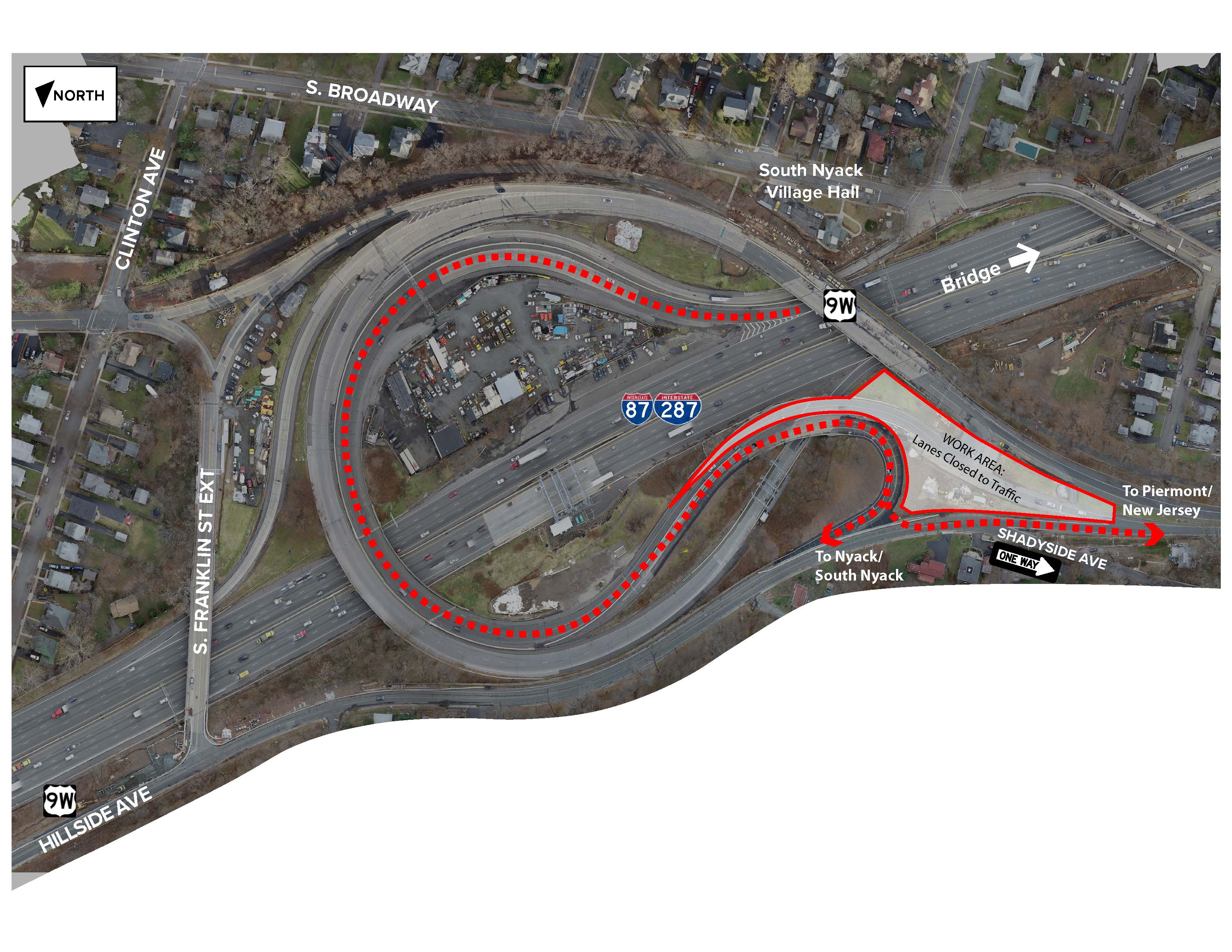
Construction of the shared bicycle and pedestrian path is moving into its next stage at the Rockland Landing. A new temporary traffic pattern will allow for the construction of a new intersection at Hillside Avenue and Route 9W.
Beginning as early as Wednesday, April 3, all motorists exiting the New York State Thruway (I-87/I-287) at exit 10 (South Nyack) will now use the ramp that recently went into service. Those headed toward Piermont and New Jersey will turn left onto Hillside Avenue/Route 9W southbound at the end of the ramp (see graphic below). Motorists turning left must first come to a full stop. Local traffic to the Nyacks will continue to bear right connecting them to Hillside Avenue to Route 9W northbound.
 Additionally, motorists will temporarily be unable to access Hillside Avenue from Shadyside Avenue. Those looking to head north on Hillside Avenue to 9W northbound will be detoured to South Boulevard and South Highland Avenue. Detour signs will be in place. Motorists will still be able to access Shadyside Avenue from Hillside Avenue (southbound, up the hill).
The temporary traffic pattern will remain in effect for several months.
Tappan Zee Constructors (TZC) will continue to install rebar, pour concrete and strip forms on the northern side of the westbound span for the bridge’s shared-use bicycle/pedestrian path, barrier and overlooks. In the coming weeks, TZC is also scheduled to begin glass installation at the overlooks.
At the Westchester Landing, foundation construction continues on the terminus site walls, the nearby storage building and canopy area. Operations include rebar installation, excavation and light pole installation.
Roadway Improvements
TZC is scheduled to continue roadway improvements near the Governor Mario M. Cuomo Bridge next week. The work requires single-lane closures on the New York State Thruway.
Specific lane closure times are listed in the chart below.
| DATE: | CLOSURES BEGIN: | CLOSURES END: | LOCATION: | |
| Mon. 4/1 | 10 a.m. – One left lane | 4 p.m. | Southbound (I-87/I-287) from exit 11 to the bridge |
|
| Tue. 4/2 | 10 a.m. – One left lane | 4 p.m. |
|
|
| Wed. 4/3 | 10 a.m. – One left lane | 4 p.m. | Southbound from exit 11 to the bridge |
|
| Thur. 4/4 | 10 a.m. – One left lane | 4 p.m. | Southbound from exit 11 to the bridge |
|
| Fri. 4/5 | 10 a.m. – One left lane | 4 p.m. | Southbound from exit 11 to the bridge |
|
East Anchor Span Removal
TZC continues to remove material from the Hudson River following the controlled demolition of the old Tappan Zee Bridge’s east anchor span, weather permitting.
Additional work includes:
- Excavation, grading, pouring concrete, drainage work and truss assembly near bridge landings
- Internal work and area preparation at the Thruway Maintenance and New York State Police facilities
- Dismantling of the old bridge’s foundations, weather permitting
Boater Safety
The western 300 feet of the 600-foot wide main navigation channel is closed to all vessel transits Monday through Saturday from 7 a.m. to 5 p.m.
Periodic partial closures of the main navigation channel are anticipated to continue during the demolition period, as TZC continues to dismantle the Tappan Zee Bridge’s west anchor span and salvage the collapsed east anchor span. Cranes, barges and other equipment will occupy parts of the channel during this time. Boaters are strongly encouraged to avoid the project site during the closures and to avoid the Regulated Navigation Areas, located east and west of the main channel.
Times and dates of the closures are subject to change and will appear in the U.S. Coast Guard’s weekly Notice to Mariners; on the project’s Twitter feed (@NewNYBridge); and broadcast on Marine Radio Channel 22A. Tappan Zee Constructors can be contacted via Marine Radio Channel 16 for assistance.
Rockland and Westchester marine units continue to patrol the project site.
More boater safety information, including the U.S. Coast Guard Notice to Mariners, a construction site map and GPS-tracked construction vessel locations, can be found at NewNYBridge.com/Boater.
The New York State Thruway Authority provides this information as a public service. Any reliance you place on such information is therefore strictly at your own risk. Nothing in these guidelines shall supersede the actual construction conditions, and regulations set forth by the U.S. Coast Guard.
All lane closures are subject to change due to traffic, weather or emergency situations. Please visit http://www.thruway.ny.gov/travelers/map/ for real-time information regarding traffic conditions.
