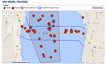
The new GPS vessel tracking map.
Governor Andrew M. Cuomo last week announced a new GPS system to track construction vessels in the area of the New NY Bridge project. Recreational and commercial boaters can now monitor the very active work zone at NewNYBridge.com
“With these new enhancements being put in place, boaters will be better protected, as will the construction crews working on the New NY Bridge,” Governor Cuomo said. “Every precaution we take on this active work zone now will not only help keep people safe, but will also keep the project on schedule and ultimately provide drivers with a less-congested commute and a safer bridge to get where they need to go.”
Displayed on an interactive map, the GPS system offers updated information on the status and movement of construction vessels on the water. The GPS tracking map is for informational purposes and not intended for navigation.
Boaters continue to be advised to use extreme caution in the area. Some 90 Tappan Zee Constructors vessels are currently on the Hudson River in the project area and at the peak of activity this summer, 130 or more vessels could be in the work zone. Crew boats, tug boats, barge mounted cranes and barges – as well as temporary fixed platforms – are in the area of the existing Tappan Zee Bridge and may be moved at any time.
More New NY Bridge boater safety information, including the U.S. Coast Guard Notice to Mariners and construction site maps, can be found here.